
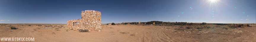
VR Panorama of the Querino Canyon Trading Post ruins. ('07) |
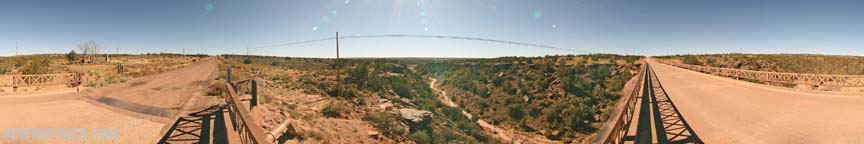
VR Panorama taken from the north side of the bridge next to the Querino Canyon Trading Post. ('07) |
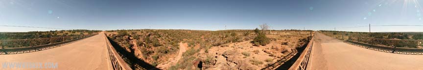
VR Panorama taken from the south side of the bridge next to the Querino Canyon Trading Post. ('07) |

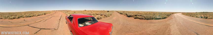
VR Panorama taken where suspected dirt '66 comes in from the east (originating from under I-40 near Navajo) and intersects Pinta Road north of I-40. It proceeds WSW to be cut by I-40 and then back WNW into the boundary of the Painted Desert and follows along paved 66 and then the south rim of the Painted Desert to the Painted Desert Inn where it proceeds westbound. It appears to be drivable by high clearance vehicles (which a Mustang is not!) ('07) |

VR Panorama taken where paved '66 comes in from the east (Navajo) and intersects the trail from the Pinta Road exit off I-40. |
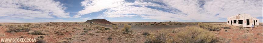
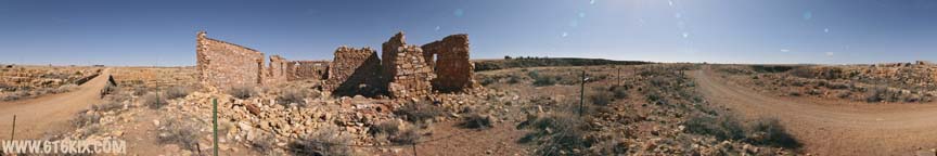
VR Panorama taken from the southeast corner of the Painted Desert Trading Post. The trading post is located on the western portion of abandoned 66 accessible from Pinta Road. ('08) |

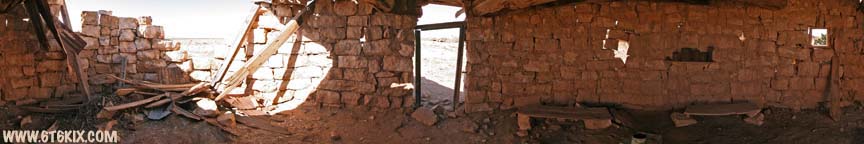
VR Panorama of the interior of the Painted Desert Trading Post. The building is essentially in ruins from time and vandalism although there is relatively little graffiti. ('08) |
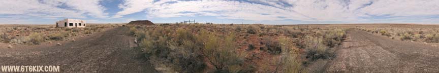
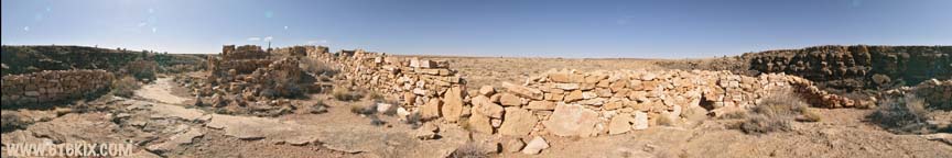
VR Panorama taken from the middle of abandoned 66 SW of of the Painted Desert Trading Post. The old bridge over Dead Wash can be seen downhill to the west. ('08) |
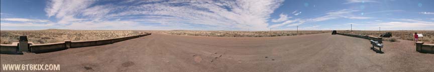
VR Panorama of where dirt '66 intersects the Painted Desert National Park road. ('07) |

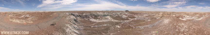
VR Panorama of the Painted Desert from the overlook at Tiponi Point. Route 66 follows along the south edge of the canyon. ('08) |

VR Panorama of the Painted Desert from 'No-Name Point' (north of Tiponi Point). There is a clearer view of the south rim as it is at a higher elevation than Tiponi Point. ('08) |
VR Panorama of the north end of the Petrified Forest Route 66 kiosk along the western side of the park road. ('08) |

VR Panorama from the south end of the Petrified Forest Route 66 kiosk along the western park road. ('07) |

VR Panorama from Tepees area of Petrified Forest National Park. These formations are located on the south side of I-40 on the park road. ('08) |

VR Panorama from the Crystal Forest in Petrified Forest National Park. The are numerous whole petrified logs and in some places the ground is literally covered with broken shards of petrified wood. ('08) |

Another VR Panorama from inside the Crystal Forest area of Petrified Forest National Park. The path here takes you past some massive petrified logs. ('08) |
A VR Panorama taken from at the south end of the Crystal Forest hiking path. This area doesn't have as many petrified logs and is more similar to the Tepees area with colored erosion layers being exposed. ('08) |
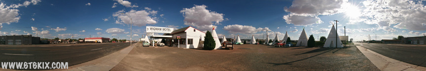
A VR Panorama of the Holbrook Wigwam Motel Office from the NW corner of the complex. ('08) |
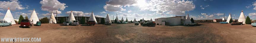
Another QTVR taken from the SW corner of the Holbrook Wigwam Motel complex in front of Wigwam #12 where we stayed. ('08) |
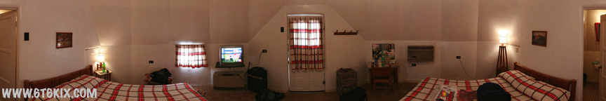
Ever wondered what the inside of a Wigwam looks like? Here is a QTVR of the inside of Wigwam #12 at the Holbrook |
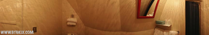
Another QTVR inside of Wigwam #12 at the Holbrook Wigwam Hotel. |

VR Panorama taken outside of the Barringer Meteor Crater visitor center. Not a bad sized hole for a 150 foot piece of iron/nickel meteor. Of course it was travelling at 26,000 mph when it hit. ('08) |
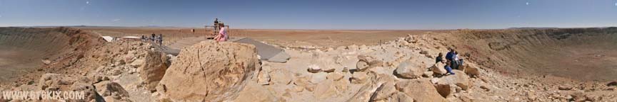
VR Panorama taken at the highest observation point on the rim of the crater. The roof of the visitor center and an observation platform down in the crater can be seen. The crater is 550+ feet deep and the rim is raised 120-200 feet above the surrounding plain. ('08) |
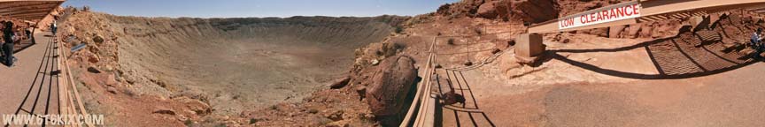
VR Panorama taken from the observation area that is built down inside the crater rim. ('08) |
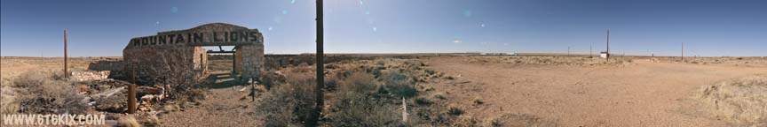 VR Panorama taken from in front of the newer well-known 'Mountain Lions' menagerie building in Two Guns. The ruins of the newer 1950's incarnation of the trading post can be seen to the north (near the small white building). ('08) VR Panorama taken from in front of the newer well-known 'Mountain Lions' menagerie building in Two Guns. The ruins of the newer 1950's incarnation of the trading post can be seen to the north (near the small white building). ('08)Click on the photo to view a 360 degree interactive virtual reality panorama. |
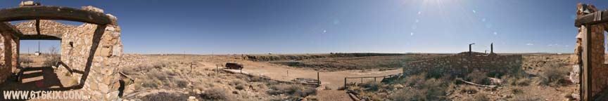
VR Panorama taken from the back of the 'Mountain Lions' menagerie building at the top of the stairs. The remains of numerous cages can be seen along the back of the building and also the 1920's 66 concrete bridge over Canyon Diablo can be seen to the south. ('08) |
VR Panorama taken at the edge of Canyon Diablo behind the 'Mountain Lions' menagerie building. There is also an old dump with a large amount of old broken bottles and rusted cans. The 1920's 66 bridge over the canyon and the original trading post can be seen to the east. ('08) |
VR Panorama taken at the south end of the bridge in front of the Two Guns Trading Post building on original Route 66 through the town. The post picked up a lot of business by locating right on the curve after crossing the bridge. ('08) |
VR Panorama taken inside of a small yet stoutly built round building west of the bridge. No particular purpose was evident but its heavy construction implies some kind of secure storage/armory or perhaps a ceremonial hogan. ('08) |
VR Panorama taken from the west side of the famous Two Guns 'Tower' Texaco station. The original menagerie building can be seen to the south and the round building and rere' dorter (2+2 holer) are to the right of the station. ('08) |

VR Panorama taken inside the entry hall in the original menagerie building. The tower of the Texaco station can be seen through the front doorway and Canyon Diablo out the back. ('08) |

VR Panorama taken inside of one of the larger rooms in the menagerie building. Canyon Diablo can be seen out the windows in the back of the building. ('08) |

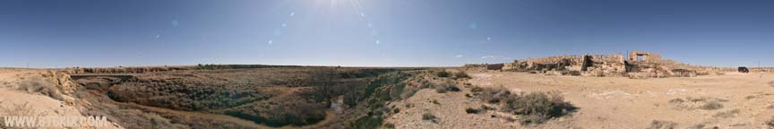
VR Panorama taken outside the back of the older menagerie building. Numerous cages can be seen lining the back of the building and the edge of Canyon Diablo is right on the pathway. ('08) |
VR Panorama in an open area on the east end of the menagerie building. The entire back of the building follows along the vertical drop into Canyon Diablo. ('08) |
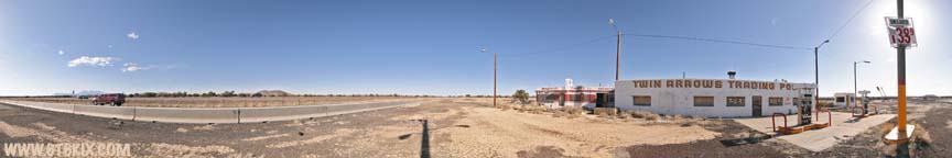
VR Panorama taken at the east end of the Twin Arrows Trading Post. The exterior of the buildings look good with only some peeling paint evident on the Valentine Diner. Note the price of gas posted on the pole <sigh> ('08) |
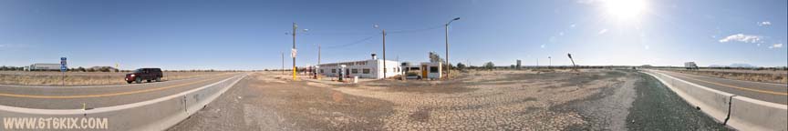
Another VR Panorama at the Twin Arrows Trading Post this time from the west end of the compound. The arrows aren't doing so good and are almost down to bare poles. ('08) |
|
VR Panorama taken from 20's and 30's 66 on the west side of Bellemont. The warehouses that can be seen in the distance were built on the south side of 40's 66 but right in the middle of the abandoned 20's and 30's 66 roadbed. ('08) |
|
VR Panorama taken from the abandoned 20's & 30's roadbed closer to where it crosses the 40's 66 pavement. ('08) |
|
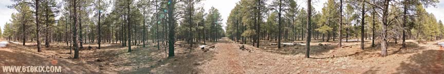
VR Panorama taken on the south side of of the 40's pavement where the 20's & 30's roadbed crosses it heading to the northwest. At this point the 20's and 30's roadbeds separate and continue on diverging paths through the trees. The 40's pavement continues for a ways west until it is overlaid by I-40. ('08) |
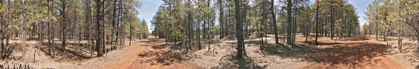
 VR Panorama taken on the north side of the 40's 66 pavement where the path of 30's 66 heads into the trees beyond the Mustang. the path of 20's 66 can be seen through the trees to the right. ('08) VR Panorama taken on the north side of the 40's 66 pavement where the path of 30's 66 heads into the trees beyond the Mustang. the path of 20's 66 can be seen through the trees to the right. ('08)Click on the photo to view a 360 degree interactive virtual reality panorama. |


|
VR Panorama taken from the middle of 20's 66 just north of where it crosses the 40's 66 pavement. A connecting road can be seen to the left that connects to the 30's 66 roadbed near the cattle guard. Straight ahead I-40 can be seen bisecting the roadbed. ('08) |
|
VR Panorama taken off the south side of the 30's roadbed where a cattle guard has been installed across it. There is no evidence of any fencing except some old barbed-wire and the wood fence posts that were attached to the crossing. The connecting road from the 20's roadbed connects in just to the left of the cattle guard. ('08) |
|
VR Panorama taken further north along the 30's roadbed. I-40 and the cut through the trees beyond can be seen ahead to the north. ('08) |
|
VR Panorama taken where the 30's roadbed is cut by eastbound I-40. It can be seen to continue on the other side. ('08) |
|
VR Panorama taken where the 20's roadbed is cut by eastbound I-40. The red asphalt is in pretty good condition here. The roadbed is being used as a dump for fallen trees. ('08) |
|
VR Panorama taken from the 20's 66 roadbed north of westbound I-40. This section is drivable in dry conditions but dead ends on private property before tieing back into the 30's roadbed. ('08) |
|
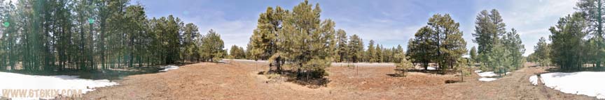
VR Panorama taken at the parking area for the Kaibab Forest Route 66 hiking & biking trail. The 30's roadbed (to the right of the Mustang) and the 20's roadbed (to the left) can be hiked to where they tie back into the 40's roadbed. To the east the combined 20's & 30's roadbeds (currently in use) come from the east and to the far left of the Mustang the current pavement can be seen to continue to tie into the 40's route. ('08) |
|
VR Panorama taken halfway down the 30's roadbed where a concrete culvert is located. ('08) |
|
VR Panorama taken off the south side of the 30's roadbed with a better view of the concrete culvert. I couldn't find any date in the concrete. ('08) |
|
VR Panorama taken from the 20's roadbed directly south of the 30's concrete culvert. If you look carefully, the culvert can be seen to the north and the 40's roadbed (still in use) can be seen to the south. ('08) |


VR Panorama taken from on top of a pile of dirt blocking the end of the bypassed old 66 railroad bridge. ('08) |

VR Panorama taken down between the old 66 bridge and the more modern replacement. The view under the bridge shows the significant repairs it had some point. Looking at the corrosion streaks it is understandable why it was replaced. ('08) |

VR Panorama taken from the middle of 66 in front of the Snow Cap in Seligman. ('08) |

VR Panorama taken under the east side overhang at Delgadillo's Snow Cap in Seligman. ('08) |

VR Panorama taken in the small memorial park behind the Snow Cap. There are numerous classic vehicles and a small seating area under the trees. ('08) |

VR Panorama taken from the middle of 66 in front of Angel's Barber and Gift Shop in Seligman. If anyone can be called the father of the Mother Road, Angel would be him. ('08) |

VR Panorama taken from the parking area on the east side of the Havasu Harvey House in Seligman. The BNSF wrecking ball will be tearing it down on April 14th, 2008. ('08) |

VR Panorama taken over the fence at the SE corner of the Havasu Harvey House in Seligman. The outside is in pretty good shape considering how long it has been abandoned. ('08) |
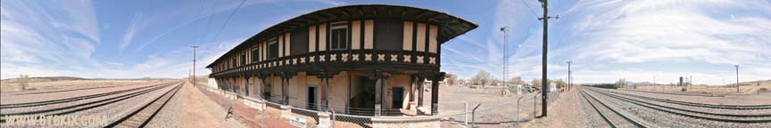
VR Panorama taken over the fence at the railroad side entryway into the Seligman Harvey House. ('08) |

VR Panorama of the Flagstaff Route 66 Car Club marshalling for the start. |

VR Panorama of Route 66 at the west end of Seligman. More cars lined up after this shot and were four deep across (not including those parked off on the sides). |

VR Panorama of the Fun Run stop in Peach Springs. They had a DJ, lots of native crafts, and tons of food available. |

VR Panorama of the west end of the Hackberry General Store stop. |

VR Panorama of in front of the Hackberry General Store. Some motorcycles found their way into the mix too. |

VR Panorama a little east with a good view of the General Store |

VR Panorama at the east end of the General Store parking area. Lots of food and drinks here too. |

VR Panorama under the carport at the Hackberry General Store. It was starting to heat up so it was getting crowded in the shade. |

VR Panorama on the west corner of the General Store. It hosts an interesting static display of collectables. |

VR Panorama at the east end of the show area. A Route 66 arch was set up for all the show cars to enter through. |

VR Panorama further east; approaching the east end entry into the show area. |

VR Panorama in front of the Harley-Davidson dealership. |

VR Panorama about halfway down the car show area. The cars were still arriving from the Fun Run. |

VR Panorama further east; more cars, more people. I particularly like the mohawk. |

VR Panorama working our way to the east down Route 66. |

VR Panorama near the park in Kingman. Lots of people and cars. |

VR Panorama in the park. Thank goodness for some shade. It was a good spot to sit and sip lemonade. |

VR Panorama in the park. Bounce houses and some REAL iron on display |

VR Panorama outside the Powerhouse. Live music but everyone was pretty much keeping to the shade as it was starting to cook in the sun. |
.
BACK TO ROUTE 66 PANORAMAS HOME.
|
|
|
|
|
|
|
|